|
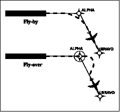
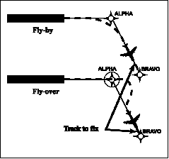
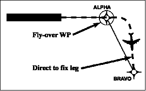
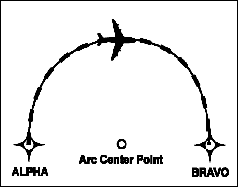
a. General. RNAV is a method of navigation that permits aircraft operation on any desired flight path within the coverage of station-referenced navigation aids or within the limits of the capability of self-contained aids, or a combination of these. In the future, there will be an increased dependence on the use of RNAV in lieu of routes defined by ground-based navigation aids. RNAV routes and terminal procedures, including departure procedures (DPs) and standard terminal arrivals (STARs), are designed with RNAV systems in mind. There are several potential advantages of RNAV routes and procedures: 1. Time and fuel savings, 2. Reduced dependence on radar vectoring, altitude, and speed assignments allowing a reduction in required ATC radio transmissions, and 3. More efficient use of airspace. In addition to information found in this manual, guidance for domestic RNAV DPs, STARs, and routes may also be found in Advisory Circular 90-100, U.S. Terminal and En Route Area Navigation (RNAV) Operations. b. RNAV Operations. RNAV procedures, such as DPs and STARs, demand strict pilot awareness and maintenance of the procedure centerline. Pilots should possess a working knowledge of their aircraft navigation system to ensure RNAV procedures are flown in an appropriate manner. In addition, pilots should have an understanding of the various waypoint and leg types used in RNAV procedures; these are discussed in more detail below. 1. Waypoints. A waypoint is a predetermined geographical position that is defined in terms of latitude/longitude coordinates. Waypoints may be a simple named point in space or associated with existing navaids, intersections, or fixes. A waypoint is most often used to indicate a change in direction, speed, or altitude along the desired path. RNAV procedures make use of both fly-over and fly-by waypoints. (a) Fly-by waypoints. Fly-by waypoints are used when an aircraft should begin a turn to the next course prior to reaching the waypoint separating the two route segments. This is known as turn anticipation. (b) Fly-over waypoints. Fly-over waypoints are used when the aircraft must fly over the point prior to starting a turn. NOTE-
Fly-by and Fly-over Waypoints |
|
|
|
Centerline to Boundary |
|
|
|
|
|
|
|
|
|
|
|
|
|
|
|
|
NOTE-
1. The "performance" of navigation in RNP
refers not only to the level of accuracy of a particular
sensor or aircraft navigation system, but also to the degree
of precision with which the aircraft will be flown.
2. Specific required flight procedures may
vary for different RNP levels.
RNP Levels Supported for International Operations
|
|
|
|
|
Projected for oceanic/remote areas where 30 NM horizontal separation is applied |
|
|
Oceanic/remote areas where 50 NM lateral separation is applied |
c. Other RNP Applications Outside the U.S. The FAA and ICAO member states have led initiatives in implementing the RNP concept to oceanic operations. For example, RNP-10 routes have been established in the northern Pacific (NOPAC) which has increased capacity and efficiency by reducing the distance between tracks to 50 NM. (See TBL 1-2-2.)
d. Aircraft and Airborne Equipment Eligibility for RNP Operations. Aircraft meeting RNP criteria will have an appropriate entry including special conditions and limitations in its Aircraft Flight Manual (AFM), or supplement. Operators of aircraft not having specific AFM-RNP certification may be issued operational approval including special conditions and limitations for specific RNP levels.
NOTE-
Some airborne systems use Estimated Position Uncertainty
(EPU) as a measure of the current estimated navigational
performance. EPU may also be referred to as Actual
Navigation Performance (ANP) or Estimated Position Error
(EPE).
1-2-3. Use of Area Navigation (RNAV) Equipment on Conventional Procedures and Routes
a. Discussion. This paragraph sets forth policy concerning the operational use of RNAV equipment for the following applications within the National Airspace System (NAS):
1. As a substitute means of navigation guidance when a VOR, NDB, DME, or compass locator facility is out-of-service (that is, the navaid information is not available); an aircraft is not equipped with conventional equipment such as ADF or DME; or the conventional equipment such as ADF or DME on an aircraft is not operational. For example, if equipped with a suitable RNAV system, a pilot might hold over an out-of-service NDB.
2. As an alternate means for navigation guidance when a VOR, NDB, DME, or compass locator facility is operational, such that the pilot can revert to the underlying guidance, as necessary, but does not normally monitor the underlying aid. For example, if equipped with a suitable RNAV system, a pilot might fly a procedure or route based on operational VOR using RNAV equipment but not monitor the VOR.
NOTE-
1. Good planning and knowledge of your RNAV
equipment are critical for safe and successful
operations.
2. Pilots planning to use their RNAV system as
a substitute means of navigation guidance in lieu of an
out-of-service navaid should advise ATC of this intent and
capability.
b. Allowable RNAV Equipment. Subject to the requirements in this paragraph, operators may use the following types of RNAV equipment as a substitute or alternate means of navigation guidance:
1. An RNAV
system with GPS or DME/DME/IRU inputs, installed in
accordance with appropriate airworthiness installation
requirements, and compliant with the equipment provisions of
AC 90-100, U.S. Terminal and En Route Area Navigation (RNAV)
Operations. Standalone GPS systems, compliant with AC 90-100,
are included in this set of equipment. A list of compliant
systems is available under "Policies & Guidance" at the
following website:
http://www.faa.gov/about/office_org/headquarters_offices/avs/offices/afs/afs400/afs410/
2. An RNAV system with GPS or DME/DME/IRU inputs, lacking the capability to automatically perform course-to-fix legs (also called path terminators), installed in accordance with appropriate airworthiness installation requirements, and otherwise compliant with the equipment provisions of AC 90-100. This subset of equipment includes some standalone GPS systems and flight management systems that are authorized for instrument flight rules (IFR) en route and terminal operations but not fully compliant with AC 90-100. However, these systems may not be used as a substitute or alternate means of navigation guidance on segments of an instrument approach, departure, or arrival procedure defined by a VOR course. This restriction does not apply to routes, which may be selected by route name or constructed by "stringing" together two or more waypoints from an onboard navigation database. Many of these systems are identified on the aforementioned website.
NOTE-
RNAV systems using DME/DME/IRU, without GPS input, may only
be used as a substitute means of navigation guidance when
authorized by NOTAM for a specific procedure, NAVAID, or
fix. The NOTAM authorizing the substitution will identify
any required DME facilities based on FAA assessment of the
DME navigation infrastructure.
c. Allowable Operations. Subject to the requirements in this paragraph, operators may use an RNAV system for the following operations:
1. Determine aircraft position over a VOR, NDB, compass locator, or DME fix.
2. Determine the aircraft position over a named fix defined by a VOR course, NDB bearing, or compass locator bearing crossing a VOR or localizer course.
3. Navigate to or from a VOR, NDB, or compass locator. For example, a pilot might proceed direct to a VOR or navigate on a segment of a departure procedure. However, pilots may not substitute for the navigation aid providing lateral guidance for the final approach segment. This restriction does not refer to instrument approach procedures with "or GPS" in the title when using GPS or WAAS.
4. Hold over a VOR, NDB, compass locator, or DME fix.
5. Fly a DME arc.
These allowances do not include navigation on localizer-based courses (including localizer back-course guidance).
NOTE-
1. No approval is required for these
operations except for operators operating under 14 CFR Part
91 Subpart K, 121, 125, 129, and 135.
2. These allowances apply only to operations conducted within the NAS.
3. The allowances defined in this paragraph apply even when a facility is explicitly identified as required on a procedure (for example, "Note ADF required"). These allowances do not apply to procedures that are identified as not authorized (NA) without exception by a NOTAM, as other conditions may still exist and result in a procedure not being available. For example, these allowances do not apply to a procedure associated with an expired or unsatisfactory flight inspection, or is based upon a recently decommissioned navaid.
4. ADF equipment need not be installed and operational, although operators of aircraft without an ADF will be bound by the operational requirements defined in this paragraph and not have access to some procedures.
5. For the purpose of this paragraph, "VOR" includes VOR, VOR/DME, and VORTAC facilities.
6. Heading-based legs associated with procedures may be flown using manual technique (based on indicated magnetic heading) or, if available, extracted from the aircraft database and flown using RNAV system guidance.
d. General Operational Requirements.
1. Pilots must comply with the guidelines contained in their AFM, AFM supplement, operating manual, or pilot's guide when operating their aircraft navigation system.
2. Pilots may not use their RNAV system as a substitute or alternate means of navigation guidance if their aircraft has an AFM or AFM supplement with a limitation to monitor the underlying navigation aids for the associated operation.
3. Pilots of aircraft with an AFM limitation that requires the aircraft to have other equipment appropriate to the route to be flown may only use their RNAV equipment as a substitute means of navigation in the contiguous U.S. In addition, pilots of these aircraft may not use their RNAV equipment as a substitute for inoperable or not-installed equipment.
4. Pilots must ensure their onboard navigation data is current, appropriate for the region of intended operation, and includes the navigation aids, waypoints, and relevant coded terminal airspace procedures for the departure, arrival, and alternate airfields.
NOTE-
The navigation database should be current for the duration
of the flight. If the AIRAC cycle will change during flight,
operators and pilots should establish procedures to ensure
the accuracy of navigation data, including suitability of
navigation facilities used to define the routes and
procedures for flight. Traditionally, this has been
accomplished by verifying electronic data against paper
products. One acceptable means is to compare aeronautical
charts (new and old) to verify navigation fixes prior
to departure. If an amended chart is published for the
procedure, the operator must not use the database to conduct
the operation.
5. Pilots must extract procedures, waypoints, navaids, or fixes by name from the onboard navigation database and comply with the charted procedure or route.
6. For the purposes described in this paragraph, pilots may not manually enter published procedure or route waypoints via latitude/longitude, place/bearing, or place/bearing/distance into the aircraft system.
e. Operational Requirements for Departure and Arrival Procedures.
1. Pilots of aircraft with standalone GPS receivers must ensure that CDI scaling (full-scale deflection) is either ±1.0 NM or 0.3 NM.
2. In order to use a substitute means of navigation guidance on departure procedures, pilots of aircraft with RNAV systems using DME/DME/IRU, without GPS input, must ensure their aircraft navigation system position is confirmed, within 1,000 feet, at the start point of take-off roll. The use of an automatic or manual runway update is an acceptable means of compliance with this requirement. A navigation map may also be used to confirm aircraft position, if pilot procedures and display resolution allow for compliance with the 1,000-foot tolerance requirement.
f. Operational Requirements for Instrument Approach Procedures.
1. When the use of RNAV equipment using GPS input is planned as a substitute means of navigation guidance for part of an instrument approach procedure at a destination airport, any required alternate airport must have an available instrument approach procedure that does not require the use of GPS. This restriction includes conducting a conventional approach at the alternate airport using a substitute means of navigation guidance based upon the use of GPS. This restriction does not apply to RNAV systems using WAAS as an input.
2. Pilots of aircraft with standalone GPS receivers must ensure that CDI scaling (full-scale deflection) is either ±1.0 NM or 0.3 NM.
NOTE-
If using GPS distance as an alternate or substitute means of
navigation guidance for DME distance on an instrument
approach procedure, pilots must select a named waypoint from
the onboard navigation database that is associated with the
subject DME facility. Pilots should not rely on information
from an RNAV instrument approach procedure, as distances on
RNAV approaches may not match the distance to the
facility.
g. Operational Requirements for Specific Inputs to RNAV Systems:
1. GPS
(a) RNAV systems using GPS input may be used as an alternate means of navigation guidance without restriction if appropriate RAIM is available.
(b) Operators of aircraft with RNAV systems that use GPS input but do not automatically alert the pilot of a loss of GPS, must develop procedures to verify correct GPS operation.
(c) RNAV systems using GPS input may be used as a substitute means of navigation guidance provided RAIM availability for the operation is confirmed. During flight planning, the operator should confirm the availability of RAIM with the latest GPS NOTAMs. If no GPS satellites are scheduled to be out-of-service, then the aircraft can depart without further action. However, if any GPS satellites are scheduled to be out-of-service, then the operator must confirm the availability of GPS integrity (RAIM) for the intended operation. In the event of a predicted, continuous loss of RAIM of more than five (5) minutes for any part of the route or procedure, the operator should delay, cancel, or re-route the flight as appropriate. Use of GPS as a substitute is not authorized when the RAIM capability of the GPS equipment is lost.
NOTE-
The FAA is developing a RAIM prediction service for general
use. Until this capability is operational, a RAIM prediction
does not need to be done for a departure or arrival
procedure with an associated "RADAR REQUIRED" note charted
or for routes where the operator expects to be in radar
coverage. Operators may check RAIM availability for
departure or arrival procedures at any given airport by
checking approach RAIM for that location. This information
is available upon request from a U.S. Flight Service
Station, but is no longer available through DUATS.
2. WAAS.
(a) RNAV systems using WAAS input may be used as an alternate means of navigation guidance without restriction.
(b) RNAV systems using WAAS input may be used as a substitute means of navigation guidance provided WAAS availability for the operation is confirmed. Operators must check WAAS NOTAMs.
3. DME/DME/IRU.
RNAV systems using DME/DME/IRU, without GPS input, may be used as an alternate means of navigation guidance whenever valid DME/DME position updating is available.